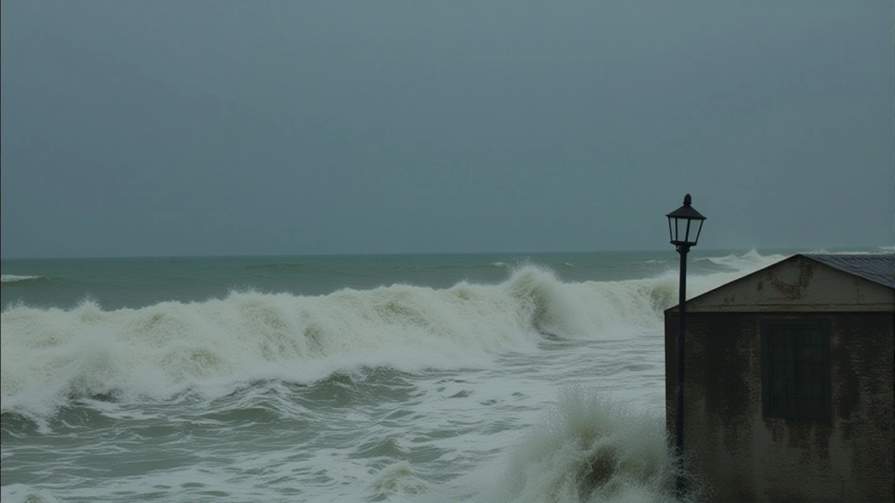
As Cyclone Montha churns toward India’s eastern coast, entire communities are bracing for a violent encounter with nature. The India Meteorological Department (IMD) has upgraded the storm to a severe cyclonic storm, with landfall expected near Kakinada in Andhra Pradesh on the evening of October 28, 2025Andhra Pradesh. At 5:30 a.m. IST on the same day, the storm’s center sat just 560 km off Visakhapatnam, but its reach already stretched hundreds of kilometers — with 85 km/h winds, 5.8-meter waves, and rain lashing Chennai’s Marina Beach. This isn’t just another monsoon storm. It’s a system that could leave behind flooded homes, downed power lines, and a shattered livelihood for thousands who live along the coast.
Why This Storm Is Different
Unlike seasonal depressions that fizzle out quickly, Cyclone Montha is being tracked with unusual precision. The Joint Typhoon Warning Center (JTWC) confirms the storm is moving northwest at 9 km/h under the influence of a strong subtropical ridge — a high-pressure system that’s essentially guiding it like a conveyor belt toward land. What’s alarming is how consistent the models are. All major forecasting systems — from the European Centre to the U.S. GFS — agree: landfall will happen between Machilipatnam and Kalingapatnam, with peak winds of 90–100 km/h and gusts up to 110 km/h. That’s Category 1 hurricane strength.But here’s the twist: even as it strengthens, the environment is turning hostile. Wind shear above 55 km/h is tearing at its outer bands, and dry air is creeping into its core — a recipe for rapid weakening after landfall. The JTWC predicts the storm will drop to 75 km/h just 12 hours before hitting shore, and vanish entirely within 24 hours after touching land. That’s not a relief — it’s a warning. Storms that weaken fast often dump more rain in a shorter time, increasing flood risk.
Emergency Measures in Motion
The response has been swift and sweeping. Indian Railways has cancelled 43 trains passing through Visakhapatnam on October 28, including services like IX2743 (Hyderabad-Vijayawada) and IX-2743 (Vijayawada-Vizag). All IndiGo and Air India Express flights from Visakhapatnam International Airport have been grounded — a rare move that signals the seriousness of the threat. Coastal districts from Tamil Nadu to Odisha are on orange alert. Fishermen have been ordered not to go out to sea from October 25 to 29. Over 1,200 relief camps have been prepped across Andhra Pradesh alone.At Chennai, the sea has turned violent. Residents report waves crashing over sea walls, and local authorities have closed public beaches. In Kakinada, school closures began Monday. The European Commission’s Emergency Response Coordination Centre (ECHO) issued a flash report on October 27, confirming the storm’s projected path between Amalapuram and Narasapur — a stretch that includes some of the most densely populated coastal villages in the region.
What Happens After Landfall?
Don’t be fooled by the prediction of rapid dissipation. When a cyclone like Montha hits land, the danger doesn’t end with the wind. Torrential rain — potentially over 200 mm in 24 hours — is the silent killer. In 2022, Cyclone Asani dumped 180 mm in 12 hours near the same coast, triggering landslides and submerging entire neighborhoods. This year, soil saturation from earlier rains means even moderate rainfall could trigger flash floods. Power infrastructure is vulnerable: 70% of distribution lines in coastal Andhra are overhead and exposed. Emergency crews are already deploying mobile generators, but restoration could take days.What’s also concerning is the human toll. Over 200,000 people live in low-lying areas directly in the storm’s path. Many are fishermen whose homes double as storage for nets and boats — assets that vanish in a single night. Local NGOs report that nearly 40% of these households have no access to formal evacuation notices — relying on word-of-mouth or radio broadcasts that may not reach them.
The Bigger Picture: Climate and Naming
The name “Montha” comes from the World Meteorological Organization’s North Indian Ocean naming list — a rotating roster of names contributed by 13 countries, including India, Bangladesh, Sri Lanka, and Oman. Montha was submitted by Thailand, meaning “moon” in Thai. It’s a poetic name for a destructive force — a reminder that even in science, we anthropomorphize nature.Climate scientists note that the Bay of Bengal has seen a 40% increase in cyclone intensity over the last 30 years. Warmer sea surface temperatures — now averaging 30°C this season — fuel stronger storms. While no single storm can be blamed on climate change, the pattern is undeniable: more storms, more speed, more damage. Montha is not an anomaly. It’s a preview.
Frequently Asked Questions
How will Cyclone Montha affect daily life in Andhra Pradesh?
Transportation has been severely disrupted: 43 trains and all commercial flights from Visakhapatnam are cancelled. Schools and markets are closed, and power outages are expected across coastal districts. Residents are being urged to stockpile water, food, and medicines for at least 72 hours. Mobile networks may become unreliable after landfall due to damaged infrastructure.
Why are fishermen being told not to go to sea for five days?
Even after the cyclone passes, the Bay of Bengal will remain dangerously rough for days. Waves of 4–6 meters are expected to persist, and strong currents can capsize even large boats. The IMD warns that returning to sea too soon could be fatal — over 150 fishermen died in similar conditions during Cyclone Phyan in 2009.
What makes the Joint Typhoon Warning Center’s forecast so reliable this time?
All 12 major global weather models — including ECMWF, GFS, and UKMET — show near-identical tracks and intensity curves for Montha. That level of consensus is rare and gives forecasters over 90% confidence in the landfall timing and location. The storm’s steady movement and lack of erratic wobble also reduce uncertainty.
Could Cyclone Montha impact cities outside Andhra Pradesh?
Yes. While landfall is focused on Andhra, heavy rain bands are expected to sweep into southern Odisha and northern Tamil Nadu. Cities like Bhubaneswar and Tirupati could see 100–150 mm of rain, triggering urban flooding. The IMD has issued yellow alerts for these regions as a precaution.
How does Cyclone Montha compare to past storms in the region?
Montha is stronger than Cyclone Vardah (2016) but weaker than Cyclone Fani (2019), which had 200 km/h winds. However, its track is more direct toward densely populated areas than Fani’s. Unlike Sidr (2007), which hit Bangladesh, Montha’s landfall zone includes major ports and industrial zones, raising economic stakes beyond just human safety.
When will normalcy return after the cyclone?
Power and communication lines could take 3–7 days to restore, depending on damage severity. Rail services may resume within 48 hours on less affected routes, but full operations could take a week. Relief agencies estimate it will take at least two weeks for coastal communities to begin rebuilding — and months for fisheries to recover.